

‘Eye in the Sky’: Pakistan’s Space Agency Uses Satellites for Flood Relief, Pakistan has been grappling with some of the most destructive floods in recent history. Torrential monsoon rains, overflowing rivers, and glacial melt have displaced millions, damaged infrastructure, and caused a humanitarian crisis. Amid this devastation, Pakistan’s space agency SUPARCO (Space and Upper Atmosphere Research Commission) has turned to satellites—an “eye in the sky”—to strengthen relief operations and assist government agencies in saving lives.
How Satellites Are Helping in Flood Relief
SUPARCO is using Earth observation satellites to monitor flood-affected areas in real-time. By analyzing satellite imagery, hydrological models, and rainfall data, the agency provides crucial insights to the National Disaster Management Authority (NDMA) and provincial disaster authorities.
Key benefits include:
- Mapping inundated areas: Satellite images highlight where water levels are rising, helping rescue teams prioritize affected regions.
- Predicting flood movement: By monitoring river flows and weather patterns, SUPARCO can forecast which areas are at risk next.
- Supporting relief operations: Relief camps, road networks, and safe zones are identified through satellite maps, making aid distribution more effective.
The Role of Technology in Humanitarian Crises
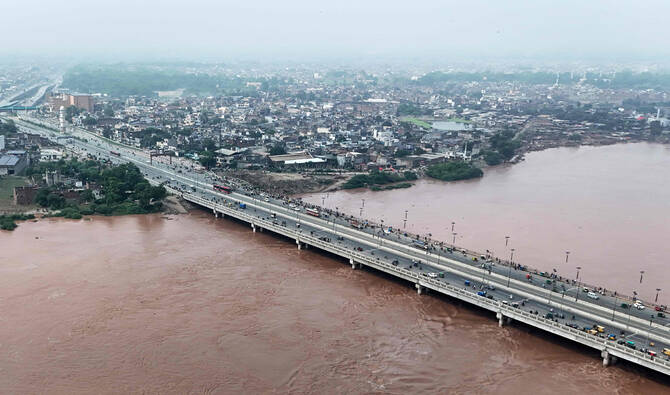
Disasters like the 2022 floods in Pakistan, which submerged one-third of the country, underline the importance of technology in crisis management. Traditional ground reports are often delayed or incomplete, but satellites deliver near-instant updates. This technology-driven approach allows authorities to act quickly, potentially preventing further loss of life.
For example, during recent floods in Punjab and Sindh, SUPARCO’s satellite images were shared with local authorities to direct rescue boats toward stranded families. Similarly, in Khyber Pakhtunkhwa, flood prediction models helped relocate vulnerable communities before rivers burst their banks.
Challenges in Implementation
While satellite technology is proving to be a game-changer, challenges remain. Pakistan still struggles with limited resources, outdated infrastructure, and lack of awareness at the community level. Many local authorities lack the technical expertise to fully utilize the advanced data provided by SUPARCO.
To overcome this, experts suggest increased collaboration between SUPARCO, universities, and disaster management agencies, as well as public awareness campaigns that teach communities how to respond to early warnings.
A Step Toward Climate Resilience
Pakistan is one of the countries most vulnerable to climate change, with rising temperatures accelerating glacial melt and making monsoons increasingly unpredictable. Investing in satellite technology and data-driven decision-making is not just about responding to floods but also about building long-term climate resilience.
By using satellites for agricultural monitoring, water management, and urban planning, Pakistan can mitigate future risks and protect vulnerable populations.
Conclusion
The devastating floods serve as a reminder that natural disasters are becoming more frequent and intense. With the “eye in the sky,” Pakistan’s space agency SUPARCO is offering a lifeline, giving relief teams the information they need to act faster and more effectively. While technology alone cannot stop the floods, it is becoming an essential tool in reducing the human and economic toll of such disasters.
For readers interested in natural solutions for resilience and recovery, you can explore Alquwwah Natural’s blog for more insights into sustainability and climate adaptation.


